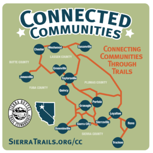
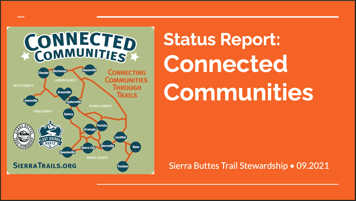
Linking 15 California Mountain Communities Through Multiuse Trails
About the Trails Master Plan
The Trails Master Plan is being developed through community input and will allow residents to collaborate with land managers and local government officials on a long-range vision for building and maintaining a world-class recreational resource on public land. The TMP will also provide a repeatable process/template for other rural communities wanting to collaborate with government agencies and stakeholders and for land managers to make informed decisions and prioritize projects based on the needs of the community.
Timing of the TMP is critical as Plumas, Lassen and Tahoe National Forests are all in the process of updating their Forest Land & Resource Management Plans. The TMP will provide timely, accurate and useful information for National Forests to plan land access, recreational trails and community needs long into the future.
Specifically, the Connected Communities Trails Master Plan will:
- Assess conditions and identify recreation priorities on Plumas, Lassen and Tahoe National Forests.
- Plan for the construction and maintenance of a world-class multiple-use trail system, connecting the 15 Northern Sierra communities
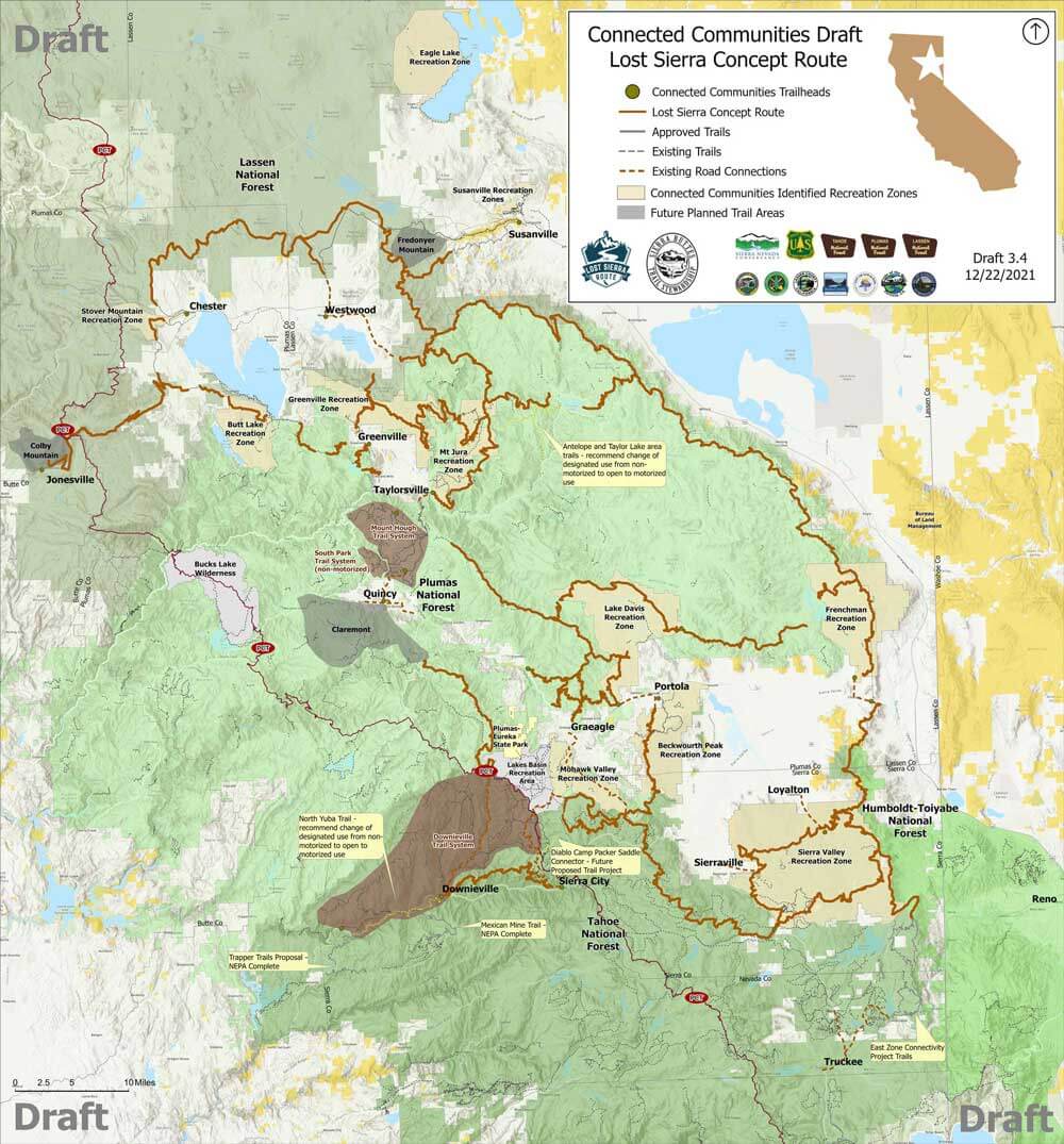
- Identify a multi-use signature route that is being referred to as “The Lost Sierra Route”, paying homage to the region and the historic Gold Rush-era mail delivery route.
- Identify areas within communities where trail access would have the highest use and easiest access, establishing “Main Street” trailheads.
- Identify unclassified National Forest roads and trails which may be decommissioned and restored to a natural condition.
- Diversity recreation opportunities throughout the region
- Create new recreational opportunities, in collaboration with fuels management and watershed protection projects, that will disperse use across the National Forest
- Bring partnerships and investment in public lands through the Outdoor Industry
The Connected Communities Project is being carried out in 4- Phases:
- Phase 1 – Planning, Mapping and Trails Master Plan Development began 2020
Paid for by Sierra Nevada Conservancy using California Proposition 68 funds - Phase 2 – NEPA/CEQA – environmental review
- Phase 3 – Lost Sierra Route Construction
- Phase 4 – Lost Sierra Route Maintenance
Phase 1 Activities
Survey the Communities
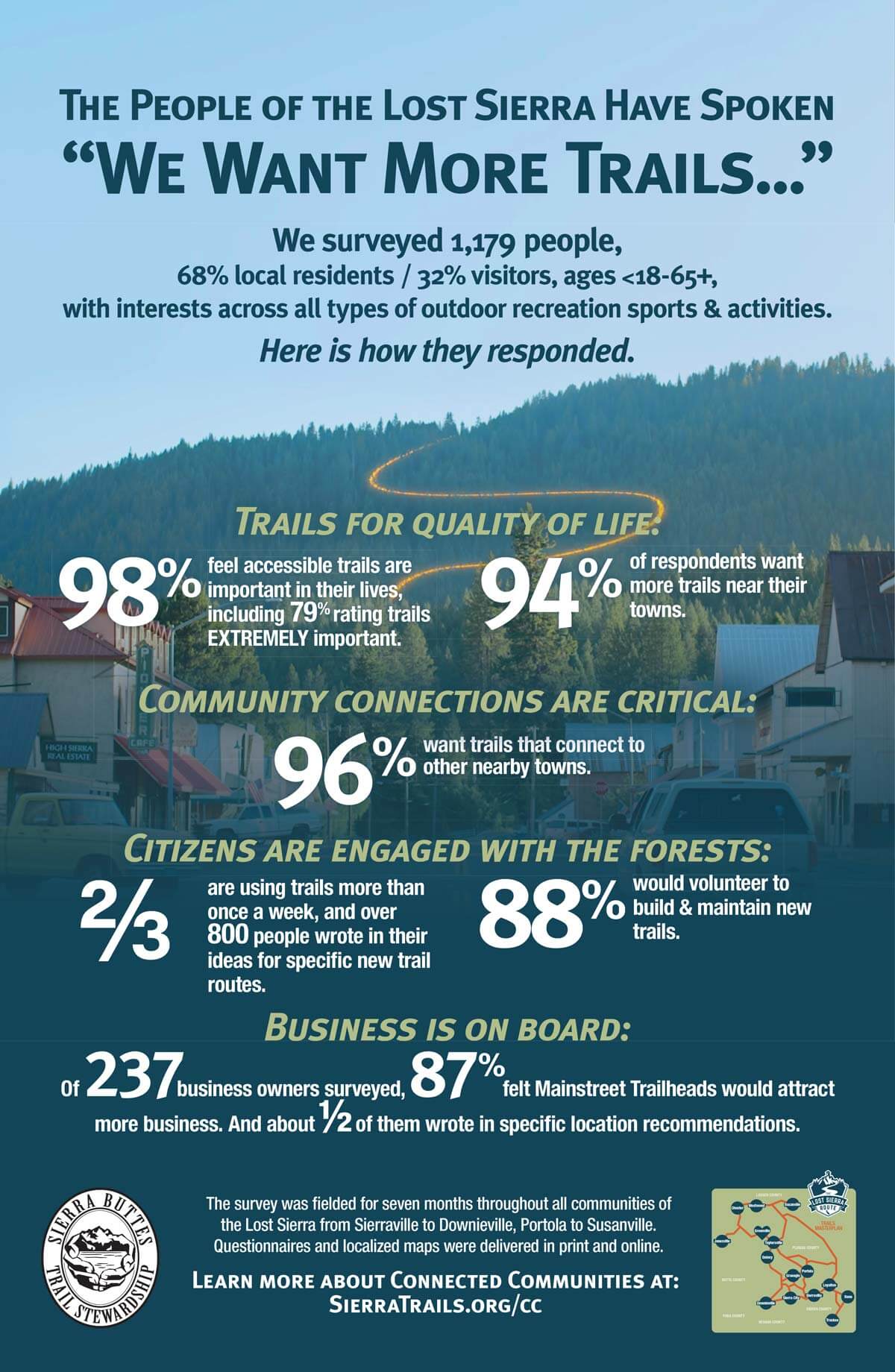
From November 2020 to March 2021, we completed a survey process to gather public input into the project. 1,179 people completed the survey, including many Lost Sierra locals who made recommendations of trail routes and trailhead locations in their communities. A comprehensive survey report was produced in September 2021 and has been distributed to land managers, local government, and project partners.
Draft Lost Sierra Route Map
From the survey reports and community meetings, concept routes have been drawn and a DRAFT Lost Sierra Route map has been created. The draft route has been submitted to Pacific Southwest Region 5 and each forest (Plumas, Lassen, Tahoe and Humboldt-Toiyabe) for review. This is a chance for the region and forests to provide feedback on the route before Environmental Analysis begins. We anticipate route modifications through these processes.
Please remember that this is a draft that has not yet been approved by the land managers and does not mean that every mile of trail will be built; however, it is nonetheless exciting to see the lines on a map and start daydreaming about future trips.
Project Status Report
For a full Connected Communities Project update please check out our Fall 2021 Status Report.
The 2021 Dixie Fire Impact
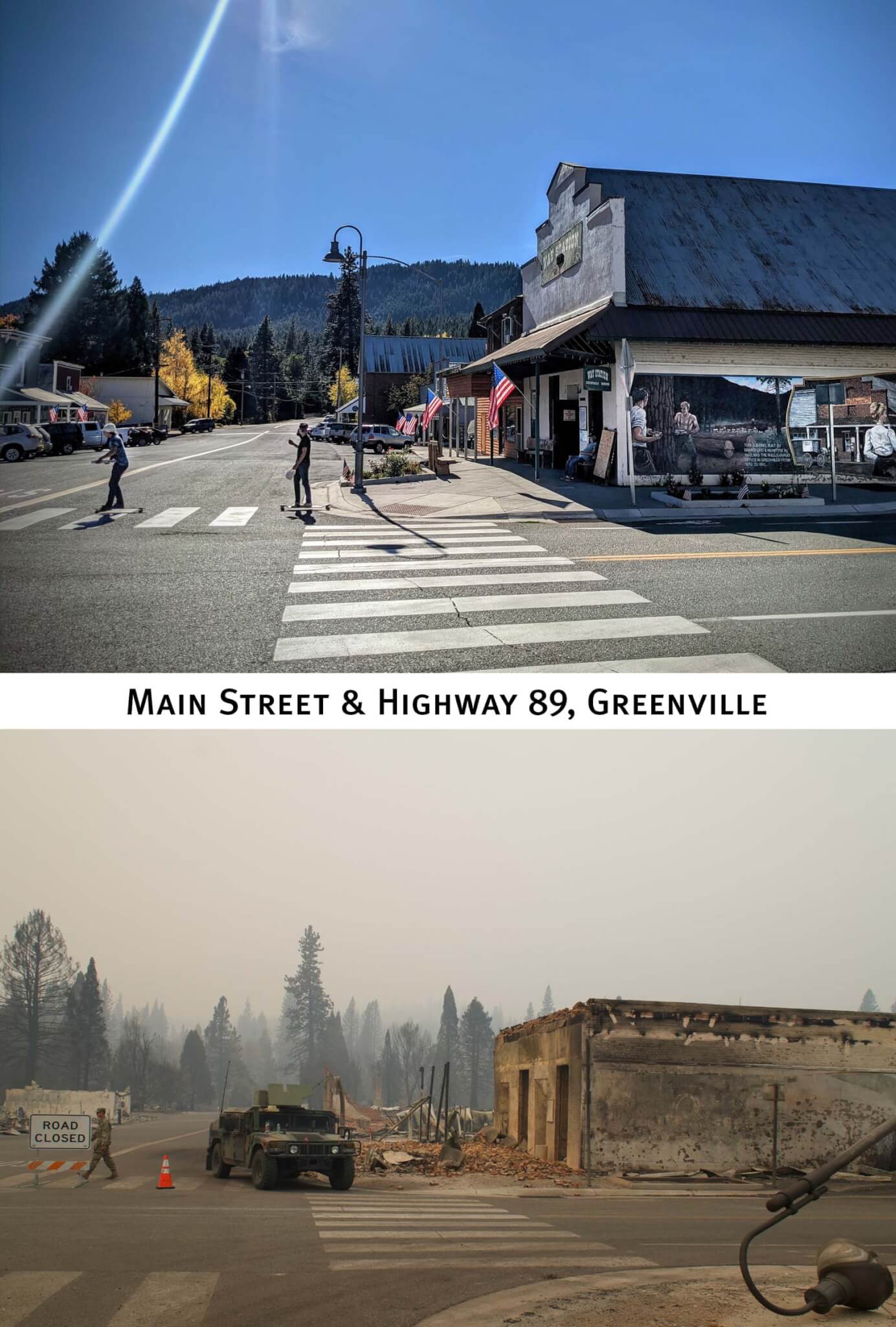
As part of Phase I planning activities, we created A Trail For Everyone which highlighted the Connected Communities Project and Lost Sierra Route concept. In the film we feature Indian Valley and the community of Greenville which has since been devastated by the Dixie Fire (the second-largest recorded fire in California history). While the Dixie Fire has had tremendous impacts to our community, trails and livelihoods, it has not obscured SBTS commitment to the Connected Communities Project. We believe that this project can help diversify recreation throughout the region and have positive economic impacts to the region, as tourism and service industries are already the second largest economic industry sector in the Lost Sierra. It will take years for the Lost Sierra communities to rebuild and heal from the traumatic 2021 fire season, and SBTS is here for the long haul as we see the Connected Communities Project as a regional resilience project for not only wildfire impacts but economic downturn too. For more on Dixie Fire impacts and ways to donate to recovery efforts please check out Hope Rises.
Connected Communities Partners
To date, project funding has been provided by Sierra Nevada Conservancy, California Off-Highway Vehicle Division grants, California State Parks & Recreation grants, California State proposition funds, National Forest Foundation grants, Secure Rural Schools, Outdoor Industry partners, Adopt a Trail sponsors and SBTS matching funds.
The list of Connected Communities partners is extensive and varied, spanning from local elected officials to government agencies and municipalities including:
Sierra Nevada Conservancy
US Forest Service, Pacific Southwest Region 5
Tahoe National Forest
Lassen National Forest
Plumas National Forest
Plumas County Board of Supervisors
Sierra County Board of Supervisors
Lassen County Board of Supervisors
Butte County Board of Supervisors
City of Portola
City of Loyalton
City of Susanville
Congressional Representative Doug LaMalfa
California State Senator Brian Dahle
California State Assemblywoman Megan Dahle
California Department of Parks & recreation
Feather River Land Trust
Sierra County Land Trust
Lassen Land & Trails Trust
Truckee Donner Land Trust
Northern California Regional Land Trust
Friends of Plumas Wilderness
Feather River Tourism Association
Lake Almanor Area Chamber of Commerce
Lassen County Chamber of Commerce
Mountain Meadows Conservancy
Sierra Business Council
Plumas Corporation
Rotary- Portola, Quincy, Susanville, Indian Valley
Sierra County Visitors Bureau
Lost Sierra Chamber of Commerce
Center for Economic Development, Cal State Chico
State of Nevada, Off-Highway Vehicle Program
Pacific Crest Trail Association
Nevada County Woods Riders
Truckee Dirt Riders
Reno Area Dirt Riders
Chico Velo
Susanville Area Bicycle Association
Tahoe Area Mountain Bike Association
Truckee Trails Foundation
Santa Cruz Bicycles
Sierra Nevada Brewing Company
Patagonia
Dolan Auto Group
Clif Bar
Shimano
Fox Shox
Wilderness Trail Bikes
Paul Component Engineering
Radius Outfitters
REI Co-op
Klean Kanteen
Voler
Camp Chef
International Mountain Bicycling Association
Economic Benefits
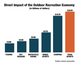
Recreation on public lands currently represents the greatest economic and cultural opportunity for our rural communities. In the United States, Outdoor Recreation is an $887 billion industry with Trail Sports accounting for $201 billion. Trails on public lands are proven to create local employment, attract visitors and new businesses, and improve the health and economy of mountain communities.
Learn More
About Sierra Buttes Trail Stewardship (SBTS)
SBTS is a Quincy, California-based 501c3 focused on building what the organization calls #dirtmagic – multiple-use motorized and non-motorized trails for public use – in the Lost Sierra region of the Northern Sierra Nevada range. Since its founding in 2003, SBTS has built over 100 miles of new trail and maintained 1,200 miles of existing trail while employing a full-time Professional Trail Crew and contributing over 100,000 hours of volunteer labor.


